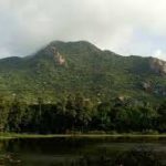
Simlipal National Park: History, Location, Geography and Climate- Simlipal National Park is a tiger reserve is located in the Mayurbhanj district of Odisha which covers an area of 2,750 km2. The Mayurbhanj Elephant Reserve, which also contains the Simlipal Tiger Reserve, Hadgarh Wildlife Sanctuary, and Kuldiha Wildlife Sanctuary, is a part of the Mayurbhanj Elephant Reserve. Simlipal National Park derives its name from the abundance of red silk cotton trees growing in the area. The park is home to the Bengal tiger, Asian elephant, gaur, and chausingha. It has been a protected area since 2009 and a component of the World Network of Biosphere Reserves established by UNESCO.
January 2023 Current Affairs Quiz
Simlipal National Park History Location
Simlipal Tiger Reserve covers an area of 2,750 km2, out of which 1,194.75 km2 forms the core area. It has the peaks of Khairiburu at 1,178 m and Meghasani at 1,158 m. The main waterfalls are the Barehipani Falls at a height of 217 m and the Joranda Falls at 181 m.
Simlipal National Park History
The Simlipal elephant reserve mainly originated as a hunting ground for royals. It was formally designated a tiger reserve in 1956 and under Project Tiger in May 1973. In 1979 “Mugger Crocodile Scheme” was started at Ramatirtha, Jashipur.
Simlipal was designated as a wildlife sanctuary by the Odisha government in 1979. Later in 1980, the state government suggested creating a national park on 303 square kilometres of the sanctuary. In 1986, the area of the national park was increased to 845.70 square kilometers. The Government of India declared Simlipal as a biosphere reserve in 1994.
UNESCO added Simlipal national park to the list of Biosphere Reserves in May 2009. 10,000 people are living in 61 villages in the forest which is why the Simlipal is yet to be declared a full-fledged park, despite its having the status of one of the 18 biospheres of India.
Simlipal National Park Geography
In the Odisha province’s Mayurbhanj district sits the Simlipal Tiger Reserve. Simlipal Elephant Reserve is an ecosystem complete with forest vegetation mainly Sal trees, fauna, and the Ho or Santhal tribal settlements. The high hills are surrounded by Meghasani/Tunkiburu, which is the highest peak in the park. At an altitude of 1,165 meters followed by Khairiburu at above 1,000 meters elevation.
12 rivers cut across the plain area of Simlipal National Park. The prominent rivers include Budhabalanga, Palpala Bhandan, Kharkai River, and Deo. Two notable waterfalls, Joranda/Jorodah (181 metres) and Barheipani/Barhai (217 metres), can also be found in the forest.
Simlipal National Park Climate
The climate of Simlipal National Park is moderate. In summer there is a hot temperature of around 40 °C whereas the winter months can be as low as 14 °C. The rainfall ranges from moderate to heavy.
Simlipal comes under a high cerebral malaria-prone zone. In cerebral malaria, the sequestrated red blood cells can breach the blood-brain barrier possibly leading to coma. Cerebral malaria, if not detected, causes death. Initial symptoms of cerebral malaria are often mistaken as those of acute jaundice. There have been many recorded cases of death due to cerebral malaria after visits to Simlipal.
In 2021, large fires broke out in the Simlipal Tiger Reserve and continued to burn for over two weeks before they were brought under control. The 2021 Simlipal forest fires resulted in widespread environmental damage and caused an exodus of fauna from the park into nearby human habitations.