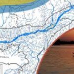
Assam is a state with two valleys (Brahmaputra and Barak Valley) framed in between 90° to 96° North Latitude and 24° to 28° East longitude. Assam encompasses total geographical area of 78,438.00 Sq. Km out of which 56,194.00 Sq. Km and 22,224 Sq. Km fall under Brahmaputra Valley and Barak Valley including 2 (Two) hill districts respectively. The estimated flood prone area of the state is 31,500.00 Sq. Km as assessed by the Rastriya Barh Ayog which is around 39.58 % of the total geographical area of Assam which itself is about 9.40% of the total flood prone area of the entire country. The estimated national flood prone area is approximately 10.2 % of the total area of the country, whereas for flood prone area of Assam, it is 39.58 % of the area of the state. It implies that the flood prone area of Assam is almost four times that of the national figure for flood prone area of the country. As per the record, average annual area affected by flood is 9.31 Lakh Hectares. Presently, the flood protected area of the state is 16500.00 Sq. Km.
The seriousness of the flood situation of the state has been intensified by the intensity of erosion on both banks of river Brahmaputra and its tributaries. Studies have shown that, up to now 4.27 Lakh Hectare area of the state has been eroded by these rivers, which is 7.40 % of the area of the state. The average annual rate of erosion is 8000.00 Hectare. The largest river island in the world, Majuli is also trapped in the jaws of erosion by Brahmaputra and about 60% of its original area has already been washed away by the river.