Uttarakhand’s Rudraprayag, Tehri top landslide index: ISRO report- According to satellite data collected over the last two decades, the two districts in Uttarakhand most at risk of landslides are Rudraprayag and Tehri. Data collected by the Indian Space Research Organisation (ISRO) has highlighted that Rudraprayag and Tehri Garhwal are at the highest risk of facing landslides, having seen the highest number of landslide incidents in the past 20 years.
March 2023 Current Affairs Quiz
More About the ISRO’s Landslide Atlas of India:
The findings, compiled by the Hyderabad-based ISRO facility the National Remote Sensing Centre, were published in the Landslide Atlas of India. The agency created a database of over 80,000 landslides in the country between 1998 and 2022 using data from ISRO satellites. The team then used this data to rank 147 landslide-affected districts across 17 states and two Union territories.
Rudraprayag and Tehri: maximum exposure to landslide risk:
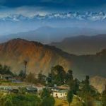
Rudraprayag and Tehri Garhwal have the “maximum exposure to landslide risk in the country” due to the presence of pilgrimage routes and tourist sites. The district is home to the Kedarnath Temple and other religious sites like the Tungnath Temple and the Madhyamaheshwar Temple.
The city of Rudraprayag itself is also a holy town due to the presence of river confluences. However, the district is also home to 32 chronic landslide zones, a large number of which are located along or around the NH-107 that leads into the town.
About The other parts of the country:
While the Himalayan region is particularly vulnerable to landslides, other parts of the country are also vulnerable. The other worst-affected districts in the country are Malappuram, Thrissur, Palakkad, and Kozhikode in Kerala, Rajouri and Poonch in Jammu and Kashmir, and South and East Sikkim.
India and risk of landslides:
India is among the four countries where the risk of landslides is the highest, the report said. Nearly 13 percent of the country’s entire land area is prone to landslides. The situation is made worse by deforestation and climate change, as forest cover helps prevent and reduce the extent of moderate landslides.
On the other hand, extreme weather events like heavy rainfall due to climate change increases soil degradation and can directly cause landslides. Landslides are the third most dangerous natural disaster in terms of deaths caused and need urgent intervention to prevent the loss of life and infrastructure in the coming years.